The miraculous rescue of the last two fishermen swept away by waves in Ly Son after...
 Timely rescue of a foreign cargo ship crew member injured from occupational accident...The Vietnam Maritime and Waterway Administration provided equipment and personnel...The specialized search and rescue vessel SAR 631 successfully rescued a fisherman...Maritime Search and Rescue Statistics (December, 2025)
 Categories
 Hotline
| HEAD OFFICES | |
| Address: | No.11A, Lang Ha Street, O Cho Dua Ward, Ha Noi. |
| Hotline: | (+84) 24.37683050 (24/24h) |
| Fax: | 024.37683048 |
| MARITIME SEARCH AND RESCUE COORDINATION CENTRE REGION 1 | |
| Address: | No.34, 33 Lane, Ngo Quyen Street, May Chai Ward, Ngo Quyen District, Hai Phong City. |
| Hotline: | (+84) 22.53759508 (24/24h) |
| Fax: | 022.53759507 |
| MARITIME SEARCH AND RESCUE COORDINATION CENTRE REGION 2 | |
| Address: | Hoang Sa Street, Tho Quang Ward, Son Tra District, Da Nang City. |
| Hotline: | (+84) 23.63924957 (24/24h) |
| Fax: | 023.63924956 |
| MARITIME SEARCH AND RESCUE COORDINATION CENTRE REGION 3 | |
| Address: | No.1151, 45 Lane, 30/4 Street, Ward 11, Ba Ria - Vung Tau City, Vung Tau Province. |
| Hotline: | (+84) 25.43850950 (24/24h) |
| Fax: | 025.43810353 |
| MARITIME SEARCH AND RESCUE COORDINATION CENTRE REGION 4 | |
| Address: | No.65, Nguyen Van Linh Street, Thanh Dat Hamlet, Phuoc Dong Village, Nha Trang City, Khanh Hoa Province. |
| Hotline: | (+84) 25.83880373 (24/24h) |
| Fax: | 025.83880517 |
 Laws & Conventions
 Website Link
 VISITOR STATISTICS
Online now: 18
Today: 811
Current month: 22626
Total: 1577037
Since 1945, over the past 70 years, data on storms and tropical depressions making landfall in Vietnam have been recorded quite fully by NOAA (United States National Oceanic and Atmospheric Administration). These records allow us to look back at storms from the past to the present in terms of landfall time, wind speed, warning level, storm center location, and other interesting facts. The P-GIS research team analyzed 459 storms that made landfall in Vietnam over the past 70 years. These data were extracted from the Asia-Pacific storm track database with more than 227 thousand storms during the same period.
.jpg)
Paths of storms hitting the East Sea and Vietnam over the past 70 years
The criteria and scope of assessment agreed by P-GIS are as follows:
- Selection of storms that make landfall: The storm's path must pass through the mainland of Vietnam. Storms that only enter Vietnam's sea but do not make landfall are not counted.
- A province that was passed through by a storm is considered to have been through the storm. Neighboring provinces, although affected by the storm, are still not counted as having been through the storm.
With the above conventions, this analysis may not truly reflect the level of impact of the storm on the provinces adjacent to the storm's path but is not counted as having been through the storm. However, looking at statistics over years and years, we may see that the country and people of Vietnam have been and are experiencing many difficulties due to the impact of natural disasters. Here are some of the analysis criteria conducted by P-GIS:
Which province has the largest number of storms
Which province has the highest warning level
Which year has the largest number of storms
Which month has the largest number of storms
Which is the most common tornado speed
Which is worthy of the title of the number one storm
Which province has the largest number of storms
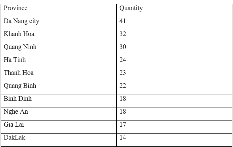
Over the past 70 years, Da Nang City and Khanh Hoa Province have had the largest number of storms. This figure does not take into account the intensity of the storms but only reflects the number. On average, each year in these two provinces, there is 1 storm that directly passes through the province.
.jpg)
Provinces that have the largest number of storms over the past 70 years
Which province has the highest warning level
The warning level of a storm is defined by the Advisory terminology developed by the US National Weather Service. On the current scale, warning levels range from 1 to 100, accordingly, a strong hurricane is typically defined with a warning level of 45-50.
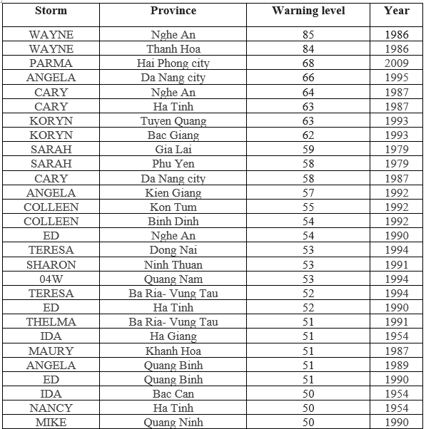
The warning levels in the table above represent the average value of all storms passing through the province in the past 70 years. It could be seen that the three provinces of Hai Phong, Thanh Hoa and Nghe An always have to endure storms with extremely high warning levels.
.jpg)
70-year average warning level of top provinces
In agricultural production planning, the usage of information on storm warning levels will help planners accurately select crop groups that are more suitable to local conditions, especially those that can withstand strong winds and heavy rains.
Which year has the largest number of storms
The number of storms does not necessarily reflect the level of destruction caused by natural disasters, but it does show the severity of the impact on people in the area where the storms pass. For tropical storms, heavy rains and whirlwinds are always the accompanying products. Therefore, when a country suffers a large number of storms, it also means that the year has had a significant impact from natural disasters.
Below is a list of the top 10 years with the largest number of storms in the past 70 years.
.png)
These are statistics for the entire territory of Vietnam over the years. It could be seen that 1973 was the "peak" year for the number of storms hitting Vietnam. Even though their intensity may not be as strong as the storms in 1989 or 1994, we can see that this record is still far from being broken.
.jpg)
Top 10 years with the largest number of storms hitting Vietnam
Which month has the largest number of storms
It is known by almost all Vietnamese people that the rainy season starts in July and ends in November every year. However, to have a clearer view of statistics, let's refer to the table below.
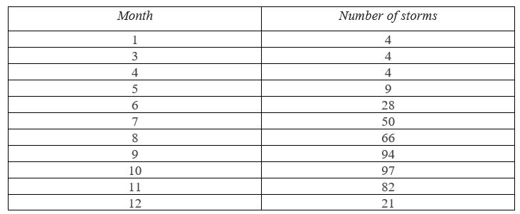
Over the past 70 years, September and October have been the two "champion" months in terms of the number of storms making landfall in Vietnam.
.jpg)
Number of storms hitting Vietnam distributed by month over the past 70 years
Which is the most common tornado speed
Despite the large number of storms, the wind speed is one of the factors that determines their level of destruction. The wind speed is measured in meters per second (m/s) at many times along the path of the storms. According to P-GIS statistics, the most common wind speed in the past 70 years recorded from data of 618 storms is 30 (m/s), followed by 25 (m/s) and 35 (m/s). It can be seen that the wind speed in storms entering Vietnam fluctuates at 25-40 (m/s) which is the most common.
(1).jpg)
Statistics of the most common wind gusts over the past 70 years
Based on Beaufort Common wind speeds in storms entering Vietnam range from level 6 to level 9.
(https://vi.wikipedia.org/wiki/Thang_s%E1%BB%A9c_gi%C3%B3_Beaufort)
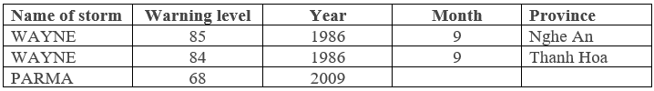
Which is worthy of the title of the number one storm
The number one storm with the highest warning level belongs to the storm named "Wayne" which appeared in 1986 and made landfall in Thanh Hoa and Nghe An provinces in September. This can be called a "super storm" as the term is being used quite commonly in the media today.